Integrated Ocean Mapping
 Less than 10% of the 3.4 million square nautical miles of the US Exclusive Economic Zone (EEZ) has been mapped with current technology, and less than 5% has been mapped in high resolution. Within this area are the ecosystems and maritime resources NOAA is expected to manage or monitor comprehensively and cooperatively.
Today, NOAA's Office of Coast Survey (OCS), our nation's leader in maintaining nautical charts for safe navigation, professionally maps our ocean floor with emphasis on coastal areas to develop charts for safe navigation. Thus, only a portion of our maritime environment is being surveyed and explored. Within NOAA, a push for integrated ocean mapping is underway, which combines the knowledge and resources of OCS with the needs and capabilities of the rest of NOAA's marine scientists and researchers.
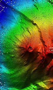
Concepts of Hydrothermal Vents
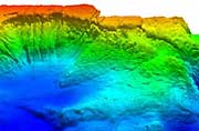
A primary product of exploration is new and improved maps. These maps differ from nautical charts by characterizing the ocean regions and documenting more than the physical environment. NOAA's Office of Ocean Exploration places great emphasis on collecting data representing multiple facets of the ocean environment including mapping the physical, biological, geological, chemical, and archaeological aspects of the ocean. These data will provide new knowledge that is necessary for comprehensively characterizing our entire marine environment from top to bottom and throughout the EEZ, and this information will serve as the foundation for new ocean science and exploration. Given the critical need for detailed maps of the ocean for science, policy and management, NOAA's Office of Ocean Exploration places a high priority on new mapping endeavors.
High resolution bathymetric mapping is a major component of several other significant research programs within NOAA such as the NOAA's Undersea Research Program (NURP) and NOAA's Pacific Marine Environmental Laboratory (PMEL). NURP also supports various other mapping initiatives such as comprehensive mapping of benthic habitats within NOAA's National Marine Sanctuary Program, and PMEL supports a major tsunami hazard assessment program within OAR to mitigate hazards to the west coast of the US, Hawaii, and Alaska. In addition, NOAA's Great Lakes Environmental Research Laboratory (GLERL) teamed with NOAA's National Geophysical Data Center (NGDC) and the Canadian Hydrographic Service to merge U.S. and Canadian historical sounding data to create improved resolution bathymetric maps and data sets for the Great Lakes.
Why is mapping our ocean important?
Many programs and offices throughout NOAA are mandated to survey ocean areas and prepare maps of hydrography, living marine resources, essential fish habitats, coral communities, hydrothermal vents, gas seeps, and marine archaeology sites. However, these surveys are often conducted as separate efforts, making it difficult to obtain, organize, and process the data collected in order to better understand how areas function as an ecosystem. Comprehensive coordinated mapping activities will better characterize the marine environments NOAA is tasked to protect, and will provide researchers a baseline for determining future management needs.
A combined integrated ocean mapping strategy will eliminate the segregation of the strongest mapping expertise in NOAA, the Office of Coast Survey, and combine that activity with the emerging needs of other programs. This investment will facilitate an important national effort to map our national resources in the sea, and provide complete information for stewardship and management of the ecosystems that we seek to define and protect.
By coordinating these activities under a single enterprise, NOAA looks to combine sensors on single platforms and conduct multiple surveys at one time. This activity is directly related to maximizing NOAA resources in survey areas, avoiding redundant research, and fostering emergent technologies and applications.
Future Interest in Mapping
Integrated ocean mapping will require coordination with NOAA research projects using NOAA or NOAA-contracted vessels consisting of sonar technology for bathymetry and habitat characterization, mid-water multibeam for pelagic resource mapping, and low frequency towed source survey for geological mapping. Additionally, this level of effort would begin with an objective of completing the mapping of the US continental shelf area and important ocean features, focusing on areas under US jurisdiction but including other areas that are unknown or poorly known.
In addition to aligning mapping efforts internally, NOAA is continuing to look externally for integrated ocean mapping support. A major component beyond NOAA's inventory of expertise is a marine geology capability to map and define geological features and resources. This deficiency may be filled with the coordinated assistance from other federal agencies, such as NOAA's long time partnership with the US Geological Survey (USGS).
Furthermore, NOAA anticipates contracting for existing and emerging capabilities in ROV, HOV, and AUV systems, for vessels within NOAA's fleet and the many academic and private platforms NOAA uses annually. These methods provide for conducting surveys at a detailed resolution, and for filming the areas as a means to verify survey data. This would further define the role for industry in ocean exploration and science, and sustain NOAA's involvement with the latest commercial ocean technology.
 Deep Sea Crabs