Solar Powered
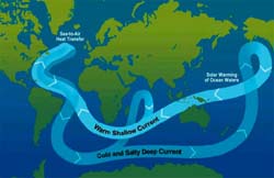
The ocean plays an essential role in the world's climate system, absorbing about half the heat from the sun. The heat escapes to warm the atmosphere, mainly through evaporation either locally or months or years later having been transported by ocean currents thousands of kilometres.
The upper three metres of the ocean can hold more heat than the entire atmosphere, and sea surface and subsurface temperatures are now used by meteorologists when they make climate forecasts.
The sun's energy also drives large-scale wind systems and cells in the atmosphere. In turn, the winds, along with sinking cold water in the polar and subpolar oceans, drive the ocean. The resulting ocean currents redistribute the energy absorbed from the sun throughout the world's oceans, carrying it away from the region of greatest heat in the tropics towards the colder polar regions.
Australia's climate variability is strongly influenced by the Pacific Ocean, the El Nio/Southern Oscillation phenomenon and sea surface temperature patterns in the Indian and Southern Oceans. Long term, the Southern Ocean is critical in evaluating the timing and regional impacts of climate change.
Ocean Circulation
Winds move across the earth's surface towards the west near the equator (trade winds) and towards the east in the temperate mid-latitudes (Westerlies and Roaring Forties). Their effects create large circulation patterns in each of the Atlantic, Indian and Pacific Ocean basins, moving clockwise north of the equator and anticlockwise south of the equator.
The gyres (or circular motions) move water from equatorial to polar regions along the eastern coasts of continents as intense warm currents (like the East Australia Current). In regions near the equator, water in the gyres also moves vertically, bringing cooler water towards the surface. When warmer water moves south towards the Antarctic, it releases its heat into the atmosphere.
In the deep ocean (at depths below about one kilometre), water movement is governed by variations in the density of water. In the Arctic and Antarctic regions, surface waters become very dense as they cool. In addition, this density is increased as sea-ice forms, releasing salts to the water. Cold saline (dense) water sinks to the bottom of the ocean, then circulates along the ocean floor, slowly mixing upwards over decades or even centuries.
Along the coastlines, local effects such as tides and coastal winds, sediments, nutrients and rainfall run-off combine to influence the behaviour of continental seas.
Physical components of an ocean
The ocean has other physical components and external influences governing its behaviour.
Waves are generated by wind and may travel thousands of kilometres across the oceans. Engineers must have a knowledge of the potential force of waves in extreme conditions when they design coastal shipping facilities and oil drilling platforms.
Ocean currents transport water in varying volumes. The Antarctic Circumpolar Current, the world's largest ocean current, can move around 150 times the volume of Sydney Harbour per second (500,000 megalitres) and even the much smaller Leeuwin Current transports five to ten 'Sydney Harbours' per second down the coastline of Western Australia. The strength, direction and volume of water carried by ocean currents can vary from season to season and from year to year, influenced in complex ways by factors such as El Nio.
In cross-section, the ocean is like an onion with many different water layers. The surface layer may be tens of metres thick. Beneath it are other layers that originate from thousands of kilometres away. For example, two of the deep layers off the Australian east coast originate in the Northern Hemisphere and in the Antarctic. Oceanographers infer the origins of these waters from their temperature and salinity, which together are effectively their signatures.
Ocean eddies are formed on the edge of strong ocean currents; they are typically 100-200 kilometres in diameter and circulate both clockwise and anti-clockwise. They are detected by satellite as roughly circular patches of high or low water and may contain currents of up to four knots, be as deep as one kilometre and circulate for several years before losing momentum. These eddies are similar to the high and low pressure systems in the weather charts. Oceanographers can track the speed and direction of ocean eddies by studying photographs taken by satellite.
Scientific interpretation of how ocean eddies form and their effects is important in mapping ocean circulation. Such information is sought by authorities such as the Australian Maritime Safety Authority for search and rescue at sea and also for environmental protection.
Upwelling is another phenomenon of oceans. It occurs when strong winds bring dense waters to the surface, against the force of gravity. Upwelling is important to the ocean ecosystems because it solves the dilemma of life in the ocean. For example, how does the food-chain begin when sunlight is only available near the surface, but essential nutrients from decaying organic matter are on the ocean floor? The answer is that upwelling returns nutrients to the surface. The richer fishing grounds of the world depend on a flourishing food chain, and it is interesting to note that Australia does not have any really rich fishing grounds because the winds here are generally not conducive to upwelling.
 Deep Sea Crabs