What is AVHRR?
- Introduction
- AVHRR
- Sea Surface Temperature and Sea Ice
- Geology
- Vegetation
- Snow Cover
- Fire Monitoring and Fuel Potential
- Glossary of Terms
Introduction
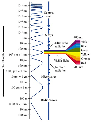
Scientists use satellites to collect information about the surface of the Earth and about the Earth's atmosphere. The satellite information is used for weather studies (meteorology), biology, geology and many other areas of scientific study. All earth-imaging satellites collect electromagnetic radiation, which can include gamma rays, ultraviolet radiation, visible light, infrared radiation, and radio waves.
The National Oceanic and Atmospheric Agency (NOAA) operates two types of satellites intended for studying meteorology. These satellites collect electromagnetic radiation in the visible light and infrared portions of the spectrum. Geostationary meteorological satellites stay in one place above the Earth, by orbiting with the Earth as it rotates, and provide continuous information for the area they can see. Polar-orbiting satellites are designed to provide complementary information to the geostationary meteorological satellites. They have a sun-synchronous, near-polar orbit, which means that a satellite travels from the North Pole to the South Pole as the Earth rotates below it. The significance of a sun-synchronous orbit is that the satellite passes over the same part of the Earth at approximately the same local time each day, ensuring comparable daylight conditions over time.
NOAA has two polar-orbiting meteorological satellites in orbit at all times, with one satellite crossing the equator in the early morning and early evening and the other crossing the equator in the afternoon and late evening. Morning-satellite data are most commonly used for land studies, while data from both satellites are used for atmosphere and ocean studies. Together they provide twice-daily global coverage, and ensure that data for any region of the earth are no more than six hours old. The swath width, the width of the area on the Earth's surface that the satellite can "see", is approximately 2,500 kilometers (about 1,500 miles). The satellites orbit between 830 and 870 kilometers (between 516 and 541 miles) above the surface of the Earth.
AVHRR
The primary sensor on board the NOAA polar-orbiting satellites is the Advanced Very High Resolution Radiometer (AVHRR). The AVHRR instrument consists of an array of small sensors that record (as digital numbers) the amount of visible and infrared radiation reflected and (or) emitted from the Earth's surface. This provides images of the Earth's surface showing elements that cannot normally be viewed with the human eye. There are 5 sensors or "channels" on board each AVHRR satellite, each designed to record information from a different part of the electromagnetic spectrum.
The highest ground resolution that can be obtained from the AVHRR is 1.1 kilometer (0.7 miles), which means that the satellite records discrete information for areas on the ground that are 1.1 by 1.1 kilometers. This smallest recorded unit is called a pixel. AVHRR data have been collected continuously since 1981.
Initially, the NOAA/ AVHRR satellites were designed to observe the Earth's weather in the form of cloud patterns. However, further research on the sensors clearly demonstrated that they could be used for more than just monitoring weather phenomena. Today the NOAA/ AVHRR satellites are used in many applications. Described below are a few such applications used by scientists around the world to observe and monitor land-surface processes and other characteristics of the Earth.
Sea Surface Temperature and Sea Ice
NOAA recognized that one of the environmental variables easiest to compute from the sensors on the AVHRR was sea surface temperature (SST). Subsequently, infrared AVHRR imagery has proven very useful in mapping mesoscale ocean features, such as currents, in terms of their SST signatures. The Gulf Stream and other major ocean currents are readily visible in SST data because their temperature is different from the surrounding water. Scientists have also developed techniques to map the variability of ocean currents from their signatures in AVHRR SST imagery.
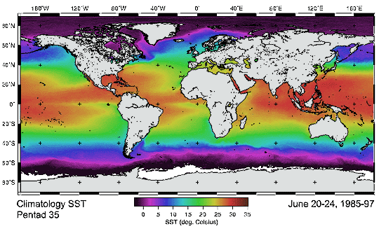
Sea surface temperatures have been known to fluctuate throughout the history of the Earth, and mapping changes in SST can help us to predict related changes in weather and marine ecosystems. For example if the warm Gulf Stream was to slowly cool, the impacts would be significant and far-reaching. Scientists believe that ocean-current changes may contribute significantly to global climate change; other impacts could include changes in the long-term health of ecosystems, as well as possible shifts in fish stocks with subsequent impacts on global fishing.
Another oceanographic application of AVHRR data is in the study of sea ice. Filtered for clouds over ice, AVHRR imagery can be used to compute sea-ice concentration and ice-edge location - both of which provide important navigation information for ships in ice-prone regions.
Geology
Geologists use AVHRR data to view large geologic formations and their surroundings, and to observe ongoing geologic events. The information available through AVHRR data assist in regional or global geological studies, such as the monitoring of volcanic eruptions and their effects on global climate change. AVHRR data have also has been used to maneuver aircraft away from potentially hazardous volcanic ash clouds.
Vegetation
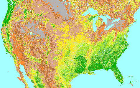
The AVHRR sensor is also a useful tool for monitoring vegetation, land cover, and climate, and enables scientists to observe how these three elements interact. AVHRR data can be used to assess the quantity and vigor (photosynthesis activity) of vegetation through a measure of "greenness", referred to as the vegetation index or the Normalized-Difference Vegetation Index (NDVI). Using AVHRR, scientists monitor the growing season of crops - which can change with variations in regional climates - and can provide potentially life saving information to developing countries that heavily rely on an abundant and reliable harvest. From AVHRR data it is relatively easy to identify green vegetation and non-vegetated features such as water, barren land, ice, snow, and clouds.
Snow Cover
Imagery from AVHRR has also proven to be useful in snow-cover mapping. The primary limitation in using AVHRR for this purpose is the similar reflectivity of clouds and snow cover, but the frequent coverage of AVHRR lessens the impact of this problem. Combined with topographic information, snow cover data from AVHRR can be converted to snow-water equivalent values to give an estimate of the amount of water reserve represented by the winter snow pack. Snow cover can also be used to analyze global climate change. For example, increasing global temperatures would be indicated by decreases in snow accumulation at higher altitudes and latitudes.
Fire Monitoring and Fuel Potential
Another use of AVHRR data lies in the monitoring of forest fires. As forest fires become intensely hot, the AVHRR sensor can record the thermal infrared signature as soon as the fire size becomes large enough to dominate the 1.1 km pixel of the AVHRR. In addition, both the visible and infrared channels will reflect the smoke plume associated with the forest fire, which assists in mapping the fire location and estimating its progress in time. This information is also beneficial to fire-fighting crews on the ground who are attempting to provide burn control. After a fire, the NDVI is used to estimate the damage done to the vegetation.
Glossary of Terms
Array - A group of smaller elements that form a complete unit.
Ecosystem - An interacting system of plants, animals, fungi, and microorganisms, and their environment.
Electromagnetic Radiation - Another term for light. Light travels in waves of various frequencies; only a small range of frequencies makes up visible light.
Electromagnetic Spectrum - The full range of frequencies, from radio waves to gamma waves, that characterizes light.
Gamma Rays - The highest-energy, shortest-wavelength electromagnetic radiations.
Global Climate Change - Alteration of temperature and precipitation patterns throughout the world.
Infrared Radiation - Electromagnetic radiation with longer wavelengths than the visible light but shorter wavelengths than microwaves.
Mesoscale - Phenomena approximately 10 to 100 kilometers (6 - 60 miles) or more in horizontal extent.
NDVI - See Normalized-Difference Vegetation Index.
Near-polar - A satellite orbit with an orbital plane within 10 degrees of a plane containing true North or true South.
Normalized-Difference Vegetation Index - An estimate of the greenness of vegetation calculated from visible and infrared satellite measurements.
Pixel - An abbreviation of picture element. The minimum-size area on the ground detectable by a remote sensing device such as a satellite. The size varies depending on the type of sensor.
Radio Waves - Electromagnetic radiation with the longest wavelength.
Radiometer - A device used for detecting and measuring radiation.
Signature - When solar radiation hits a surface, it may be transmitted, absorbed or reflected. Different materials reflect and absorb differently at different wavelengths. The greater the amount of radiation absorbed the warmer the surface. The recording of these different wavelengths by the sensor onboard the satellite is referred to as a spectral signature.
Sun-synchronous - A satellite orbit such that the satellite passes the equator and each latitude at the same time each day. The orbital plane of a sun-synchronous orbit must also process (rotate) approximately one degree each day, eastward, to keep pace with the Earth's revolution around the sun.
Topographic - Showing the relief of the land.
Ultraviolet Radiation - Electromagnetic radiation with a shorter wavelengths than visible light but longer wavelengths than x-rays.
Visible Light - Light that can be seen by the human eye.
 Deep Sea Crabs