Aegean and Black Sea 2006
From April to June 2006, scientists from the University of Rhode Island lead an expedition to study the archaeology and geology of the Aegean and Black Seas aboard two research vessels, the Greek R/V AEGAEO and the University of Rhode Island's R/V ENDEAVOR External Link. The Institute for Exploration's (IFE) ROV's Hercules and Argus were utilized, as well as IFE's side-scan sonar ECHO. April 26 - June 16, 2006. From April to June 2006, scientists from the University of Rhode Island lead an expedition to study the archaeology and geology of the Aegean and Black Seas.
This Cruise was Divided Into Three Segments, Each with Different Research Goals:
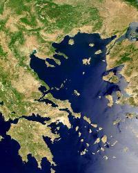
![]() A geophysical and archaeological survey in the Sea of Crete, in the southern Aegean.
A geophysical and archaeological survey in the Sea of Crete, in the southern Aegean.
![]() An investigation of the distribution of volcanic sediments from Thera (Santorini).
An investigation of the distribution of volcanic sediments from Thera (Santorini).
![]() An archaeological survey in the northern Black Sea, off the shores of Ukraine.
An archaeological survey in the northern Black Sea, off the shores of Ukraine.
The Sea of Crete has been a crossroads of maritime activity in the eastern Mediterranean region for thousands of years. This is the first season of a multi-year geological and archaeological study in the Sea of Crete. Our interdisciplinary research team of archaeologists and oceanographers will correlate geographic and cultural information as we consider interactions between humans and the sea. We aim to describe navigational routes and their hazards; to clarify questions about the nature and organization of communications among inhabitants of the Aegean and Mediterranean Seas, including trade and colonization; and, to correlate the archaeological record with the geological stratigraphy of the Sea of Crete.
For each segment of this mission, there were two survey phases. We used side scan sonar and sub-bottom profiling to locate archaeological targets; this was followed by closer investigation of targets using remotely operated vehicles (ROVs) Argus and Hercules to photograph and collect high-definition video imagery of each target. Still and visual imagery will be analysed by scientists both at sea and on shore to determine if it is geological or archaeological.This record of remains of human activity will provide valuable information about travel and commerce throughout the long history of this maritime crossroads.
 Deep Sea Crabs